Facts
Travel
Hotels
Restaurants
Business
Photos
|
Maps of Brasília
See also:
 Brasília Brasília
 Brasília Maps Brasília Maps
South Hotels Sector - Setor Hoteleiro Sul
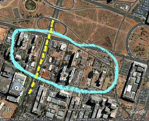
The image below shows an aerial view of the South Hotels Sector in Brasília. For a broader view, check out this aerial map of Brasília.
 The Southern Hotel Sector is the area within the circle. The Southern Hotel Sector is the area within the circle.
Notice that, despite the name South, the sector is located in the central area of Brasília. Check out this map of the Hotel Sectors and this other one of the Northern Hotel Sector.
The sector offers a variety of small and large hotels, with prices varying accordingly.
Check this link for a list of some of the hotels in Brasília.
The large rectangular building to the right is a large center of shops and offices, with the misleading name of Southern Fun Sector. The dashed yellow line is the W3, one of the main thoroughfares in Brasília, through which most buses circulate; it is worthy noticing that there are a few bus lines, quick and cheap, which connect the hotel sectors to the Brasília airport.
Because of the central location, the hotel is near some important points of Brasília, like the Three Powers Square (about 5 km), the Palácio do Buriti (about 2 km), the Convention Center (about 2 km), the central bus station (about 500 m).
Also, there are some shopping centers around the hotels, the largest of which is the Pátio Brasil, the large rectangle in the lower left corner of the photo.
Update: World Cup in Brasilia.
The National Stadium is located about 2 km West of the Hotels Sector; the North Hotel Sector is little bit closer to the stadium than the South Sector.
Because of a FIFA policy, most vehicles are not allowed to reach within 2 miles of the stadium; this means that the easiest way to go from the hotels to the stadium is by walking.
|
|


 The Southern Hotel Sector is the area within the circle.